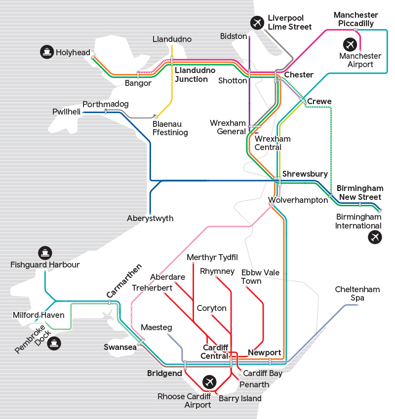
How to use the map
Use our map to plan your route and find your railway station.
The" view station location" menu shows where the station is on our network.
Click on your station dot to show the accessibility rating and click on the station name to open a map of the surrounding areas.
The "view station local area map" menu shows the available walking and cycling routes within 5 miles and click on the icons for facilities and cycle parking at our stations. Use the toggles in the search bar to select which route you would like to view.
All local area maps are available to be exported or printed using the "print" button.
We’re only able to display information for stations operated by Transport for Wales.
Transport for Wales is not responsible for the maintenance or availability of active travel routes.
View station location
Aber (ABE)
Abercynon (ACY)
Aberdare (ABA)
Aberdovey (AVY)
Abererch (ABH)
Abergavenny (AGV)
Abergele and Pensarn (AGL)
Aberystwyth (AYW)
Albrighton (ALB)
Alderley Edge (ALD)
Ammanford (AMF)
Baglan (BAJ)
Bangor (Gwynedd) (BNG)
Bargoed (BGD)
Barmouth (BRM)
Barry (BRY)
Barry Docks (BYD)
Barry Island (BYI)
Betws-y-coed (BYC)
Bidston (BID)
Bilbrook (BBK)
Birchgrove (BCG)
Birmingham International
Birmingham New Street (BHM)
Blaenau Ffestiniog (BFF)
Bodorgan (BOR)
Borth (BRH)
Bow Street (BOW)
Bridgend (BGN)
Brithdir (BHD)
Briton Ferry (BNF)
Broome (BME)
Buckley (BCK)
Bucknell (BUK)
Builth Road (BHR)
Bynea (BYE)
Cadoxton (CAD)
Caergwrle (CGW)
Caerphilly (CPH)
Caersws (CWS)
Caldicot (CDT)
Cardiff Bay (CDB)
Cardiff Central (CDF)
Cardiff Queen Street (CDQ)
Carmarthen (CMN)
Cathays (CYS)
Cefn-y-Bedd (CYB)
Cheltenham Spa* (CNM)
Chepstow (CPW)
Chester (CTR)
Chirk (CRK)
Church Stretton (CTT)
Cilmeri (CIM)
Clarbeston Road (CLR)
Clunderwen (CUW)
Codsall (CSL)
Cogan (CGN)
Colwyn Bay (CWB)
Conwy (CNW)
Coryton (COY)
Costford (COS)
Craven Arms (CRV)
Crewe (CRE)
Criccieth (CCC)
Crosskeys (CKY)
Cwmbach (CMH)
Cwmbran (CWM)
Cynghordy (CYN)
Danescourt (DCT)
Deganwy (DGY)
Dinas Powys (DMG)
Dinas Rhondda (DNS)
Dingle Road (DGL)
Dolau (DOL)
Dolgarrog (DLG)
Dolwyddelan (DWD)
Dovey Junction (DVY)
Dyffryn Ardudwy (DYF)
Earlestown (ERL)
East Didsbury (EDY)
Eastbrook (EBK)
Ebbw Vale Parkway (EBV)
Ebbw Vale Town (EBB)
Energlyn and Churchill Park (ECP)
Fairbourne (FRB)
Fairwater (FRW)
Fernhill (FER)
Ferryside (FYS)
Ffairfach (FFA)
Fishguard and Goodwick (FGW)
Fishguard Harbour (FGH)
Flint (FLN)
Frodsham (FRD)
Garth (Bridgend County) (GMG)
Garth (Powys) (GTH)
Gilfach Fargoed (GFF)
Glan Conwy (GCW)
Gloucester (GCR)
Gobowen (GOB)
Gowerton (GWN)
Grangetown (GTN)
Gwersyllt (GWE)
Harlech (HRL)
Haverfordwest (HVF)
Hawarden (HWD)
Hawarden Bridge (HWB)
Heath High Level (HHL)
Heath Low Level (HLL)
Helsby (HSB)
Hengoed (HNG)
Hereford (HFD)
Heswall (HSW)
Holyhead (HHD)
Hope (Flintshire) (HPE)
Hopton Heath (HPT)
Johnston (Pembs) (JOH)
Kidwelly (KWL)
Kilgetty (KGT)
Knighton (KNI)
Knucklas (KNU)
Lamphey (LAM)
Leominster (LEO)
Lisvane and Thornhill (LVT)
Liverpool Lime St (LIV)
Liverpool South Parkway (LPY)
Llanaber (LLA)
Llanbedr (LBR)
Llanbister Road (LLT)
Llanbradach (LNB)
Llandaf (LLN)
Llandanwg (LDN)
Llandecwyn (LLC)
Llandeilo (LLL)
Llandovery (LLV)
Llandrindod (LLO)
Llandudno (LLD)
Llandudno Junction (LLJ)
Llandybie (LLI)
Llanelli (LLE)
Llanfairfechan (LLF)
Llanfairpwll (LPG)
Llangadog (LLG)
Llangammarch (LLM)
Llangennech (LLH)
Llangynllo (LGO)
Llanharan (LLR)
Llanhilleth (LTH)
Llanishen (LLS)
Llanrwst (LWR)
Llansamlet (LAS)
Llantwit Major (LWM)
Llanwrda (LNR)
Llanwrtyd (LNW)
Llwyngwril (LLW)
Llwynypia (LLY)
Ludlow (LUD)
Lydney (LYD)
Machynlleth (MCN)
Maesteg (Ewenny Road) (MEW)
Maesteg (MST)
Manchester Airport (MIA)
Manchester Oxford Road (MCO)
Manchester Picadilly (MAN)
Manorbier (MRB)
Merthyr Tydfil (MER)
Merthyr Vale (MEV)
Milford Haven (MFH)
Minffordd (MFF)
Morfa Mawddach (MFA)
Mountain Ash (MTA)
Nantwich (NAN)
Narberth (NAR)
Neath (NTH)
Neston (NES)
Newbridge (NBE)
Newport (South Wales) (NWP)
Newton-le-Willows (NLW)
Newtown (NWT)
Ninian Park (NNP)
North Llanrwst (NLR)
Oakengates (OKN)
Pantyffynnon (PTF)
Pembrey and Burry Port (PBY)
Pembroke (PMB)
Pembroke Dock (PMD)
Pen-y-bont (PNY)
Penally (PNA)
Penarth (PEN)
Pencoed (PCD)
Pengam (PGM)
Penhelig (PHG)
Penmaenmawr (PMW)
Penrhiwceiber (PER)
Penrhyndeudraeth (PRH)
Pensarn (PES)
Pentre-Bach (PTB)
Penychain (PNC)
Penyffordd (PNF)
Pont-y-pant (PYP)
Pontarddulais (PTD)
Pontlottyn (PLT)
Pontyclun (PYC)
Pontypool and New Inn (PPL)
Pontypridd (PPD)
Port Talbot Parkway (PTA)
Porth (POR)
Porthmadog (PTM)
Prees (PRS)
Prestatyn (PRT)
Pwllheli (PWL)
Pye Corner (PYE)
Pyle (PYL)
Quakers Yard (QYD)
Radyr (RDR)
Rhiwbina (RHI)
Rhoose Cardiff International Airport (RIA)
Rhosneigr (RHO)
Rhyl (RHL)
Rhymney (RHY)
Risca and Pontymister (RCA)
Rogerstone (ROR)
Roman Bridge (RMB)
Ruabon (RUA)
Runcorn (RUN)
Runcorn East (RUE)
Sarn (SRR)
Saundersfoot (SDF)
Severn Tunnel Junction (STJ)
Shifnal (SFN)
Shotton (SHT)
Shrewsbury (SHR)
Skewen (SKE)
Smethwick Galton Bridge (SGB)
Stockport (SPT)
Sugar Loaf (SUG)
Swansea (SWA)
Taffs Wells (TAF)
Tal-y-cafn (TLC)
Talsarnau (TAL)
Talybont (TLB)
Telford Central (TFC)
Tenby (TEN)
Tir-Phil (TIR)
Ton Pentre (TPN)
Tondu (TDU)
Tonfanau (TNF)
Tonypandy (TNP)
Trefforest (TRF)
Trefforest Estate (TRE)
Trehafod (TRH)
Treherbert (TRB)
Treorchy (TRY)
Troed-y-Rhiw (TRD)
Ty Croes (TYC)
Ty Glas (TGS)
Tygwyn (TYG)
Tywyn (TYW)
Upton (UPT)
Valley (VAL)
Warrington Bank Quay (WBQ)
Waun-gron Park (WNG)
Wellington (Shropshire) (WLN)
Welshpool (WLP)
Wem (WEM)
Whitchurch (Salop) (WTC)
Whitchurch (WHT)
Whitland (WTL)
Wildmill (WMI)
Wilmslow (WML)
Wolverhampton (WVH)
Wrenbury (WRE)
Wrexham Central (WXC)
Wrexham General (WRX)
Ynyswen (YNW)
Yorton (YRT)
Ystrad Mynach (YSM)
Ystrad Rhondda (YSR)
